|
|
|
|
|
|
India - Pakistan - Iran - Turkey - Syria - Jordan - Lebanon - Syria - Turkey - Europe Reisverhalen, grensovergangen, de auto en de opdrachten in het Nederlands |
 |
| Date | GPS | Location | Story |
| 23 - 25 December 2003 |
N30Ḟ11'22.0" E67Ḟ0'18.5" |
Quetta (1712 m) |
The last stop before Iran! This means buying alcohol, fruit juice, engine oil and all the other goodies not available in Iran. We celebrated Christmas with a luxurious buffet in the beautiful Serena Hotel. For less than 4 euro... |
| 22 December 2003 | N29Ḟ14'26.6" E71Ḟ3'9.1" |
Uch Sharif (105 m) |
The setting of the 14th century Sufi shrines in Uch Sharif is superb. Also the fact that the shrines are partly in ruins, due to a flood in 1817, gives the monuments a mystical atmosphere. |
| Uch Sharif |  |
||
| 21 December 2003 | N30Ḟ11'22.2" E71Ḟ27'11.1" |
Multan (120 m) |
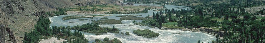
When we visited Multan in August 2002 it was 35 degrees centigrade 24 hours a day. But now in wintertime it was very pleasant and therefore we visited the beautiful 14th century mausoleums. |
| 20 December 2003 | N31Ḟ34'7.5" E74Ḟ18'27.7" |
Lahore (208 m) |
The Lahore Museum, already famous in the days of Kipling's Kim, is a not to be missed. Even if you are in a hurry... |
| 12 - 19 December 2003 |
N33Ḟ42'17.6" E73Ḟ5'17.3" |
Islamabad (533 m) |
Yes, also for non-US and non-UK citizens getting an Iranian visa means waiting, waiting and more waiting. When we finally got it, we had only 6 days left on our Pakistani visa and 2300 km to drive to the Iranian border! |

| |||
| 9 - 11 September 2003 |
N34Ḟ0'10.2" E71Ḟ32'47.0" |
Peshawar (346 m) |
A visit to Toyota Frontier for some final denting and painting jobs on our LandCruiser. |
| 1 - 8 December 2003 | N33Ḟ42'27.8" E73Ḟ2'19.6" |
Islamabad (556 m) |
Back in Islamabad to visit the workshop of the Northern Areas Education Project, to apply for the Iranian visa and for our finals lessons horseback riding at the Islamabad Club. Dutch: Consultant in Pakistan. |
| 30 November 2003 | N34Ḟ55'45.3" E72Ḟ52'41.5" |
Besham (619 m) |
A stop-over on the way to Islamabad. |
| 27 October - 29 November 2003 |
N35Ḟ55'21.9" E74Ḟ18'50.6" |
Gilgit (1494 m) |
We are doing an one month project for the Aga Khan Education Service. A final report about the field based teacher training and the community school development project has to be written. Furthermore we assisted the Aga Khan Rural Support Programme with the writing of proposals. |

|
Info: Dutch: |


|
Info:
|
| 18 August 2003 | N34Ḟ37'10.3" E73Ḟ6'24.2" |
Sharkul (1674 m) |
Although the Pakistanis work hard on it, the KKH is still not completely repaired and therefore the 600 km from Gilgit to Islamabad takes 2 days. |
| 13 - 17 August 2003 |
N35Ḟ55'21.9" E74Ḟ18'50.6" |
Gilgit (1494 m) |
14 August: Partition Day! Celebrated in Gilgit with a special polomatch. 15 August: Bastiennes second birthday during this travel! Bastienne made Dutch apple pie for the people at Madina Guest House. Dutch: Opdracht 13 - Jarig op reis. |
| 10 - 12 August 2003 |
N36Ḟ9'33.0" E74Ḟ10'54.0" |
Naltar (2902 m) |
Because of its many pine trees, Naltar valley is often called "little Switzerland". There are, however, some differences:
|
| Naltar girl |

| ||
| 6 - 9 August 2003 | N35Ḟ55'21.9" E74Ḟ18'50.6" |
Gilgit (1494 m) |
Back in our second home, Madina Guest House. Info: New GPS coordinates of places we visited. Dutch: Opdracht 9 - De prijsindex bijgewerkt. |
| 5 August 2003 | N36Ḟ19'26.9" E74Ḟ40'8.2" |
Karimabad (2404 m) |
One day of hassle to get some cash on our credit card. So quickly back to Gilgit. Not as beautiful as Karimabad, but at least with some facilities. |
| 1 - 4 August 2003 | N36Ḟ31'16.9" E75Ḟ21'37.3" |
Shpodeen Pass (5350 m) |
Do I have to go down here?!?!? That's what you think at the top of the Shpodeen Pass. But after a few days trekking in the Karakoram you know that when you succeed in eliminating your vertigo impossible descents and ascents become possible. After the pass you enter the Zardgarben valley. A place were you expect every moment an army of orcs and trolls to come out of the caves to go after you. A bizar place. |
| 27 - 31 July 2003 | N36Ḟ26'53.7" E75Ḟ40'24.0" |
Shimshal Pamir (4723 m) |
The Gojal area consists mostly of steep barren rocks, but the high altitude valleys like the Shimshal Pamir are beautiful alpine pastures with grass, flowers, yaks and sheep. Trekking here is uncomparable with trekking in Nepal: no lodges or tea-houses, no easy trails, only goat trails, whitewater rivers to ford, steep rocks to climb - trekking in the Karakoram means adventure! |
| 24 - 26 July 2003 | N36Ḟ19'26.9" E74Ḟ40'8.2" |
Karimabad (2404 m) |
Back in Karimabad to arrange a trekking and to clear our e-mail account from junkmail. |
| 22 - 23 July 2003 | N36Ḟ21'7.0" E74Ḟ40'37.6" |
Ultar Meadow (3295 m) |
From Karimabad it is a short but steep walk to Ultar Meadow, a small and green meadow surrounded by Ultar (7388 m), Boyohagur (7329 m), |

|
Hunza peak (6270 m) and Bubulimating (6000 m). If that's not enough, you have the Ultar icefall which is more than 1000 meter high. An unbelievable scenery for a meadow with a size of 2 kilometer! We camped here two nights, spending one day hiking to Hon Pass (4287 m) for an aerial view of Hunza valley and the half dozen 7000 m peaks surrounding it. |
| 20 - 21 July 2003 | N36Ḟ19'26.9" E74Ḟ40'8.2" |
Karimabad (2404 m) |
Karimabad or Baltit is the former capital of the Hunza Kingdom. The Baltit fort, the ancient guardian of the valley, is beautifully restored and from here you have a superb view of the Hunza valley and the massive Rakaposhi (7788 m) and Diran (7266 m) mountains. Seen from the village the fort is dwarfed by the Ultar mountain (7388 m). Dutch: Opdracht 26 - Karimabad zet Namche Bazaar in de schaduw. |
| 19 July 2003 | N36Ḟ27'39.9" E74Ḟ53'34.7" |
Passu (2518 m) |
The Passu Glacier almost swallows the KKH. From the village, or better, from the remarkable restaurant Glacier Breeze you have a beautiful view of the glacier and of the magical Passu Cones. |
| 17 - 18 July 2003 | N36Ḟ25'57.1" E74Ḟ51'40.1" |
Borith Lake (2667 m) |
From Borith Lake it is an easy walk to the moraine of the Ghulkin Glacier, from which you have an excellent view of the glacier itself. |
| 10 - 16 July 2003 | N35Ḟ55'21.9" E74Ḟ18'50.6" |
Gilgit (1494 m) |
A week of rest and time to arrange trekking in the Karakoram. Info: Where to buy beer, coffee and toilet paper? |
| 6 - 9 July 2003 | N36Ḟ5'0.8" E72Ḟ32'22.4" |
Shandur pass (3711 m) |
Gilgit - Chitral, the highest polo-match in the world! If you need a reason to visit Pakistan, then this is it. A spectacular game, with a spectacular mountain scenary and a spectacular Mad Max like setting. BBC's Michael Palin was filming the event, so if are not convinced yet, wait for his program about the region later this year. Don't wait too long to book a flight to Islamabad and Gilgit for July 2004! |

| |||
| Dutch: Een uitgebreid verhaal over de trip naar de Shandur pas. | |||
| 4 - 5 July 2003 | N35Ḟ55'21.9" E74Ḟ18'50.6" |
Gilgit (1494 m) |
Back in the Karakoram and back in Madina Guest House, one of the nicest places of our travels. |
| 3 July 2003 | N35Ḟ8'34.8" E73Ḟ3'6.0" |
Dasu (954 m) |
Due to an Earth quake and lots of rain the Karakoram Highway is severly damaged since our last visit. Therefore we could not drive in one day to Gilgit and had to camp just before the village of Dasu. |
| 27 June - 2 July 2003 |
N33Ḟ42'17.6" E73Ḟ5'17.3" |
Islamabad (533 m) |
What a delight to be back in Pakistan! Relaxed trafic, polite and helpful people, good roads, and on top of that there is the six lane highway to Islamabad and the pleasant city of Islamabad itself. After 7 months of India and Nepal this feels like coming back to Earth. |

| |||
| Dutch: "Mijnheer, Uw Carnet is verlopen." |
|
Picture copyright owned by Erwin Voogt. Please contact me first if you want to use any of these pictures for any purpose. |