
|
|
|
|
|
|
India - Pakistan - Iran - Turkey - Syria - Jordan - Lebanon - Syria - Turkey - Europe Reisverhalen, grensovergangen, de auto en de opdrachten in het Nederlands |
 |
| Date | GPS | Location | Story |
| 15 November 2002 | N31°36'14.5" E74°34'10.6" |
Border Pakistan - India | The Monty Python like border-closing ceremony, performed each day on both the Pakistani side and the Indian side of the border, was an amazing ending of three months Pakistan and the start of many months India. We were warned for lots of hassle and baksheesh on the Indian side of the border, but the Indian officials appeared to have improved their behaviour and the crossing of the border went smooth as it should go. Dutch: Een uitgebreid verhaal over de opnieuw verrassend soepele grensovergang. |
| 12 November - 14 November 2002 |
N31°33'41" E74°19'7.9" |
Lahore (202 m) |
Try to forget the noise and smell of countless autorickshaws and you're walking in probably the most glamourous city of the Indian Subcontinent. Beautiful Mughal and classy Victorian buildings, nice parks and gardens, luxurious shops and the superb Lahore Museum - Lahore would be a World Class city if it did not suffer from severe pollution. And a little bit less staring by the Pakistani males would also help... |
| 6 November - 11 November 2002 |
N33°42'17.6" E73°5'17.3" |
Islamabad (533 m) |
The nice thing about Islamabad is that it's only 15 km from Pakistan. This common saying refers to the fact that Islamabad is unlike any other city within a radius of 5000 km and that it is 15 km from its sister Rawalpindi. Islamabad was created 40 years ago and is a very green, quiet and luxurious and a rather Western city. The campsite is located in a park in the middle of the city. We even saw some wild animals passing close to our vehicle and our campfire on one night! |
| 31 October - 6 November 2002 |
N34°0'10" E71°32'47" |
Peshawar (342 m) |
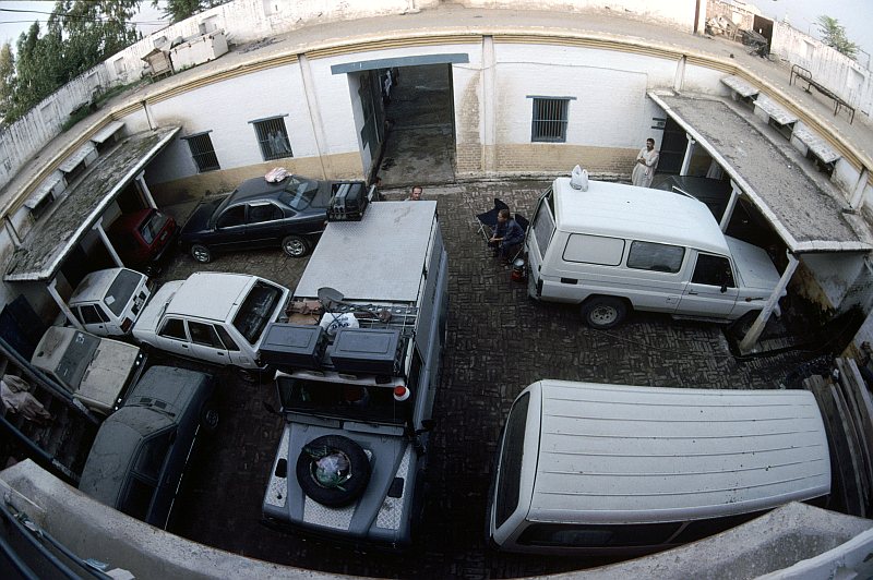
Toyota Frontier Service is doing the last repairs on our LandCruiser. It took a long time, but they did a miracle job. The car looks like new. |
| 30 October 2002 | N33°6'46" E70°52'14.9" |
Latamber (461 m) |
We were invited by a manager from Toyota Frontier to visit his family in Latamber, a small Pashtun village located in the so called Tribal Areas. The protected life of Pashtun women is somewhat unfamiliar for us Westerners, but the horrifying stories in Western media have little to do with reality. We also hiked into the Salt Mountains and a family trip is incomplete without firing some rounds with an AK-47. Also grandmums pistol had to be tested. In these areas "Stop, or my mum will shoot" should be taken very seriously. |
| 29 September - 31 October 2002 
|
N34°0'10" E71°32'47" |
Peshawar (342 m) |
We have to wait here until our car is fixed. Peshawar is a comfortable city and the magnificent Khyber pass is next door! Info:
|
| 28 September 2002 | N35°12'5.6" E71°52'37.3" |
Dir (1364 m) |
One of the strangest nights until now: sleeping inside a wrecked LandCruiser, in the back of a colourful Pakistani Bedford truck, parked at the Dir police-station... |
| 26-27 September 2002 |
N35°51'4.7" E71°47'14.5" |
Chitral (1520 m) |
We had to wait until transport to Peshawar was available. Watching polo in a mountain scenery almost make you forget the problems of past and coming days! |
| 25 September 2002 | N36°16'12.4" E72°14'55" |
Booni (2088 m) |
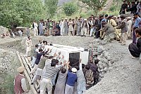
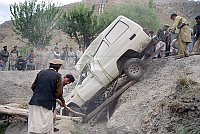
Today our LandCruiser was winched out of the ditch with a lot of help from the Awi village and the Booni police. We owe a lot of thanks to all the people that helped us! |
|
Click for a map of the route in Northern Pakistan |
|
||
| Dutch: Het hele verhaal in het Nederlands. | |||
| 24 September 2002 View this place in Google Earth. |
N36°16'31.3" E72°19'4.6" |
Awi (2112 m) |
Accident! Heading for Gilgit, we took the road at the wrong
side of the river. At a narrow turn in this tiny dirt-road our car
slide of the edge and fell on its side 2 meters below on an irrigation
channel. Due to the crash I lost consciousness for a few minutes and my memory was gone. Only after a few hours sleep my memory returned, besides a gap from 13:30 (an hour before the accident) to 1:00 (the time I woke up after two hours of sleep). |
| 22-23 September 2002 |
N35°41'15.7" E71°39'55.9" |
Krakal (2140 m) |
The Kalash valley is home to the Kalasha, non-Muslims who claim
to be descendent of ancient Greek colonists. The story goes that
Alexander the Great was very surprised to find Greeks around here
when he came over the Hindukush in 327 BC. Besides its intriguing population, the Kalash valley is also very green and beautiful. Unfortunately, with the Afghan border within 20 km, hiking possibilities are limited for security reasons. |
| 20-21 September 2002 |
N35°51'4.7" E71°47'14.5" |
Chitral (1520 m) |
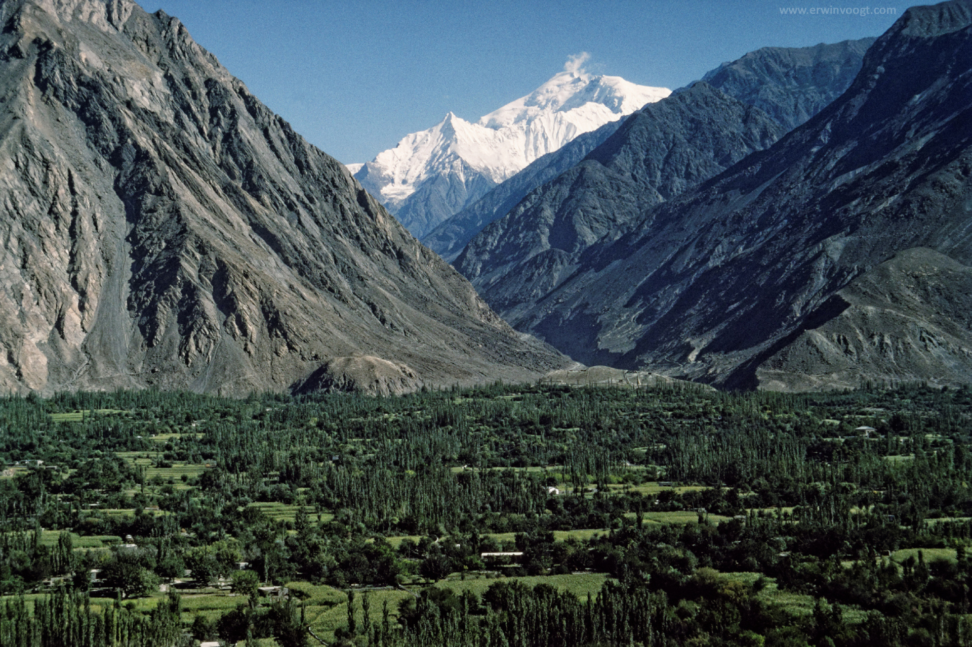
A pleasant mountain village with a beautiful sight at the
Tirich Mir, with 7706 m the highest mountain of the Hindukush. The Chitral Gol National Park is home of the elusive snow leopard. |
| 16-19 September 2002 |
N34°0'10" E71°32'47" |
Peshawar (342 m) |
A colourful and comfortable Pasthun city. Also home of several UNHCR sites, and UNHCR LandCruisers and tents are everywhere. We are still wondering why the UNHCR uses the most luxury and powerful LandCruisers available instead of the common ones like ours. According to the newspapers many Afghan refugees are wondering the same. |
| 15 September 2002 | N34°17'16.7" E71°56'48.8" |
Tahkt-i-Bahi (390 m) |
Not again! For the third time the police showed up just when we had dinner at our beautiful camping spot next to the ancient Buddhist monuments of Tahkt-i-Bahi. Again the argument was that this place was unsafe and that we had to stay at the police-station. The police-station was small and a policeman guided the parking: "come, come, [scratch]... stop". Thanks again pal... Anyway, it was an odd place to camp: next to jail with prisoners looking through the bars and next to a bullet riddled car with fresh blood-spatters inside. The policemen told us that a complete family had been killed inside that car. Nice information to get some good night's rest. |
|
|||
| 14 September 2002 | N35°28'56.3" E72°35'10.1" |
Kalam (2048 m) |
Upper-Swat is the most beautiful part of the Swat valley. Next to the Forest Resthouse we found a nice camping spot. Also this time our dinner was disturbed by a visit of the police: it was considered unsafe for foreigners outside the village. We had to go to a hotel or camp at the police-station... |
| 13 September 2002 | N35°3'11.6" E72°33'40.4" |
Miandam (1848 m) |
A summer-resort for rich Pakistanis. |
| 12 September 2002 | N35°15'33.3" E73°12'57.7" |
Komila (836 m) |
The hotels in the twin village Dasu/Komila were just crap and so
we decided to camp next to the KKH near some tea-stalls. The owners of
the tea-stalls assured us the spot would be safe to stay the night. For some reason the police found out about us and just while we were having dinner they dropped by: it was considered unsafe to stay here so we had to move to the police-station. |
| 9-12 September 2002 |
N35°55'21.9" E74°18'50.6" |
Gilgit (1494 m) |
A few days of rest at the pleasant Madina Guesthouse. We also replaced the glowplugs... |
|
|||
| 8 September 2002 | N35ş7'51.2" E75ş1'39.6" |
Kharam (3070 m) |
Our car almost fell into the river 30 meter below but you get used
to this kind of events when driving in the Karakoram. Also watched a mountain village polo match. Superb! |
| 7 September 2002 | N35ş4'33.5" E75ş32'8.8" |
Ali Malik Pass (4153 m) |
Beautiful high altitude fields, the Deosai Plains, offering a superb camping spot. We knew that the glowplugs of our engine were damaged and the night-frost punished us for our imprudency. Furthermore the cold caused a strange car problem: the condensation of diesel vapour in the tank resultated in a vacuum in the tank. It took us two hours to recognise the problem. Just loosen the tankcap and "problem yok" as they would say in Turkey! 
|
| Dutch: Autopech op 4100 meter. | |||
| 6 September 2002 | N35ş26'45.8" E75ş27'9.9" |
Karpia (2366 m) |
A small peasant village near Skardu. |
| 5 September 2002 | N35ş55'21.9" E74ş18'50.6" |
Gilgit (1494 m) |
On the way back we gave a ride to a border officer and his broken UPS. Futhermore our car was hit by a falling rock, causing the removal of some paint. Don't worry: as we will later learn a Pakistani policeman helping you parking your car will give more reason to visit a paintshop. |
| 4 September 2002 View this place in Google Earth. |
N36ş50'47.0" E75ş25'35.9" |
Khunjerab Pass (4717 m) |
The highest point of the Karakoram Highway offers the following items:
|
|
Click for a map of the route in Northern Pakistan |
|
||
| Dutch: Het hele verhaal over de KKH! | |||
| 3 September 2002 | N36ş25'54.5" E74ş51'40.0" |
Borith Lake (2656 m) |
Next stop at the KKH: another beautiful mountain lake. |

|
|||
| 2 September 2002 | N36ş15'8.6" E74ş32'22.2" |
Minapin (2055 m) |
We planned a full day hiking trip to the glaciers at the base of
the superb Rakaposhi (7788 m). Due to bad weather we limited our
walking day to an afternoon. You get a little bit lazy when travelling by car... |
| 30 August - 1 September 2002 |
N35ş55'21.9" E74ş18'50.6" |
Gilgit (1494 m) |
Madina Guest House in Gilgit is one of the most enjoyable places of
Pakistan. Normally Madina accommodates 30 to 40 travellers. Due to 911 only 8 tourist stayed here, including us! View this place in Google Earth. |
| 30 August 2002 | N34ş52'15.8" E73ş41'44.9" |
Girdas Pass (4300 m) |
A engineer guided us to the new road he was blasting out of the rocks. Of course, no decent surface yet, but at least no end of life when making a small driving mistake; this blasting new trail was about 3 meters wide. |
|
Click for a map of the route in Northern Pakistan |
|
||
| 29 August 2002 | N35ş7'10.1" E73ş58'31.4" |
Gittidas (3677 m) |
Following a hair-raising rocktrail we reached the settlement of
Gittidas. A definition of hair-raising? Simple: it is not possible to open a door of your car. Left: a wall of sharp rock. Right: 500 meters of free fall down to the river below. |
| 27-28 August 2002 | N34ş52'15.8" E73ş41'44.9" |
Saiful Muluk (3228 m) |
The destination we wanted to reach on August 25: A beautiful lake surrounded by massive mountains. View this place in Google Earth. |
| 26 August 2002 | N34ş36'52.0" E73ş25'17.8" |
Kawai (1450 m) |
A lot of hassle to get out of Kashmir and find the right road. Only in the afternoon we arrived at the entrance of the Kaghan valley. An engineer of the Pakistan army directed us to a beautiful camping spot next to a river. |
| 25 August 2002 | N33ş55'17.7" E73ş26'17.9" |
Bhurban (2037 m) |
Due to a landslide and some misunderstanding we ended up in this
Kashmiri hill-station. Officially a warzone as we found out the next day. Hotels refused to accommodate us, so we camped in front of an army base.
Dutch: Het verhaal over de KKH tot en met 5 september. |
| 24 August 2002 | N31ş31'12.1" E74ş18'37.4" |
Lahore (222 m) |
Just a stop-over. Later we will visit this great city with more interest. |
| 23 August 2002 | N30ş11'22.2" E71ş27'11.1" |
Multan (120 m) |
The reach the North we have to pass through Multan and Lahore. The direct route north is tribal area and not allowed for foreigners (and unsafe). Anyhow, we had some glimpse of the Pashtun tribal dresses. The most funny burka is the one with a small top on the head and coloured white or pink. Not kidding: those women look like walking condoms! |
| 21-22 August 2002 | N30ş22'13.1" E68ş35'55.6" |
Loralai (1444 m) |
Since Bam
we travelled with Wendy and Arie, driving in a
LandRover 110. The road between Ziarat and Loralai is terrible
(average speed 25 km/h) and since Wendy is feeling ill we decided
to stop in this nothing-special town. Dutch: The site of Wendy and Arie |
| 20 August 2002 | N30ş22'31.5" E67ş42'40.6" |
Ziarat (2613 m) |
An English hillstation. |
| 18-19 August 2002 | N30ş11'22.0" E67ş0'18.5" |
Quetta (1712 m) |
Was the difference between (Eastern) Turkey and Iran not really big, Pakistan is another galaxy. Chaotic, male dominated streets, bad roads, dirt and garbage everywhere but also less serious and more funny people, excellent food and all Western goodies available. |
| 17 August 2002 | N28ş58'37.6" E61ş33'1.1" |
Border Iran - Pakistan |
What do you expect from this border crossing? We got this: only a few stamps and hassle, no vehicle search at all, free coke, free water, free food (the best food we had in two months!) and a secure place to camp also for free! Thank you, custom officers of Pakistan, also for the lots of laughs! |

|
|||
| Dutch: Een uitgebreid verhaal over dit warme welkom in Pakistan. |
|
Picture copyright owned by Erwin Voogt. Please contact me first if you want to use any of these pictures for any purpose. |
|